Arctic Sea Ice Extent, Arctic Sea Ice Area, Arctic Sea Ice Volume, the Northwest Passage and Northeast Passage.
My Original Predictions
Arctic Sea Ice Extent = 4.2m km2 +/- 0.2m km2Current numbers (approximate):
Arctic Sea Ice Area = 2.95m km2 +/- 120k km2
Arctic Sea ice Volume = 5,500 km3 +/-500 km3
Arctic Sea Ice Extent = 5.2m km2Arctic Sea Ice Extent
Arctic Sea Ice Area = 3.269
Arctic Sea Ice Volume = 6,600 km2
 |
| The green line is roughly the minimum 2007 Arctic Sea Ice Extent; the yellow line indicates a rough guess for minimum 2011 Arctic Sea Ice Extent based on current areas of very low extent sea ice; and the orange and pink hatched areas are the areas of difference between the two years. Images from UIUC. |
- Thinner ice is more prone to breaking up and once a chunk breaks off it will obviously drift.
- Without getting too technical, let's say there haven't been strong or persistent weather patterns that moved the ice in any one direction, leaving it to drift into available space.
As it stands, my prediction for Extent, just slightly more than for 2007, seems to have been low, and I can't remember why since I wasn't expecting a new record. There is an indication of another Dipole Anomaly setting up which potentially could accelerate movement of ice and ice loss via wind direction and higher temperatures. If a strong Dipole does develop, a new record is well within the range of the possible. The strong caveat comes from how spread out the ice is at this time.
Another consideration is the Arctic Oscillation (AO) which is generally predicted to begin moving toward neutral and possibly go positive by September. A positive AO is associated with cooler temperatures in the Arctic indicating slower, less or no melt is possible.Still, given there are as many as three more weeks of melt season left, we could see a new extent record.
Judge for yourself the state of the ice (Images taken from here.):

 |
| Image I |
 |
| Image II |
 |
| Image III |
Arctic Sea Ice Area
 |
| Arctic Sea Ice Area from BPIOMAS. |
The melt season, like pretty much all natural phenomena, is not linear. Over the past weeks this has been amply illustrated. We've seen Arctic Sea Ice Area decline slow, speed up and even seen the area increase. This pattern is probably more likely as the season comes to an end and the Arctic cools over all. Cooler days may see ice growth while warmer days will see it decline. The ice season also has no clear rhyme or reason; it could end in ten, twenty or thirty days.We are still looking likely to see a new record for ASI Area. This measurement tries to determine the actual area of ice, not ice and open water between floes as extent does, so it is a little less dependent on winds and currents for short term changes, though obviously weather and temperatures do drive changes.
I won't be surprised if we hit the low end of my error bar (2.83m km2) if conditions favor melt. As with extent, whether the Dipole Anomaly develops or the AO goes positive will make a difference, and potentially a large difference.
Arctic Sea Ice Volume

Volume is the most important estimate, in my opinion, because it reflects all the forces affecting the Arctic Sea Ice: irradiance, air temperatures, sea temperatures, weather. It gives an excellent sense of the condition of the ice when there is divergence between extent and volume, for example, because you know the ice must be thinner if extent is higher than the record, yet volume is lower.
Northwest Passage
The Northwest Passage is filled with much at this point. Those white specks are the ice floes under the clod cover. The scale here is about 20 km./inch, so there is plenty of room to maneuver, though ice obviously should be treated with great caution.

This image is from the 16th. You can see much of the really small mushy ice has melted away.
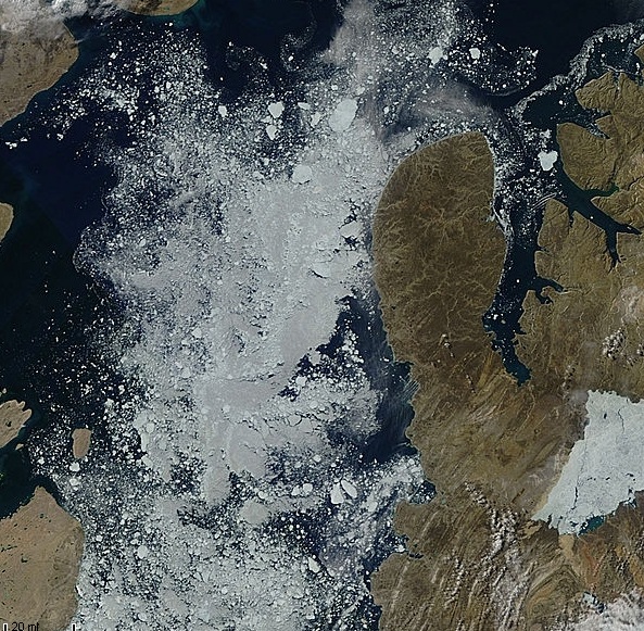
I'm not expecting the Parry Channel to clear completely, but it is clearly navigable. The southern route would be safer, but is longer by a good 300 miles.
Northeast Passage
 | ||||||
| Yellow lines outline clouds, blue lines ice. |

The key point here is that the both the Northwest and Northeast Passages are opening every year, and earlier each year. This illustrates the effect of thin sea ice. It takes very little energy and bad weather for the ice at the outer reaches of the Arctic to melt out. This year it was extremely early. The Northeast Passage was officially open for ice breaker-guided shipping on June 30th, and open, by my estimate, for traffic soon after that.
No comments:
Post a Comment
Comments appreciated, but be polite; I like to edit.
Cheers